GGOS Intergovernmental Committee (GIC) White Paper (Draft)
Modern society counts on reliable information and the products of International Association of Geodesy (IAG) Services, e.g. the global reference frames, EOP as fundamental contributions for positioning and navigation in many fields of global, regional and national applications. Moreover, geodesy plays an essential role in providing the metrological basis for monitoring changes in the system Earth through a global geodetic infrastructure.
A commitment to provide these products in a sustainable long-term manner can only be ensured by governmental agencies, while science organisations i.e. IAG assure an improving quality and adherence to necessary standards. Therefore the existing and planned global and national activities of governmental agencies should be discussed and coordinated by a GGOS Intergovernmental Committee (GIC).
Being established the GIC will lobby for a long term commitment to further build up and operate a global network of geodetic observatories with optimum spatial coverage and the resulting products.
A major goal of NASA and solid Earth science in the 1970's was the development of satellite laser ranging (SLR) and very long baseline interferometry (VLBI) techniques to accuracy levels that would enable the scientific problems to be addressed. By the late 1970's, confidence in the viability of these measurement techniques justified initiation of an international program.
Since the late 1980s, the U.S. Global Positioning System (GPS) constellation of satellites has come to play a major role in regional and global studies of Earth.
During the 1980's, the NASA Crustal Dynamic Project (CDP) (http://cddis.nasa.gov/programs.html#CDP ) and its international partners have made measurements of crustal motion between numerous sites (partly mobile occupations) around the world.
The Bureau International de l'Heure (BIH) initiated in its AnnualReport for 1984, 1985, 1986, 1987 the publication of a terrestrial reference frame based on a combination of the space geodetic data received from various analysis centres and provide a conventional terrestrial frame consistent with the BIH ERP, named BIH Terrestrial System (BTS).
Since the establishment of the International Earth Rotation and Reference Systems Service (IERS) in 1987 BTS was replaced by ITRFXX, latest ITRF2008 (in preparation).
In the 1990’s paradigm change from observation campaigns to permanent observation stations, especially in GNSS applications, because of the increasing number of receivers and the advantage of continues observations e.g. orbit determinations, station variability.
As a result creation of the International GNSS Service (IGS) which was recognized in 1993 by the International Association of Geodesy (IAG), and began routine operations on January 1, 1994, providing GPS orbits, tracking data, and other data products in support of geodetic and geophysical research. Today the IGS products are an essential and mandatory source also for business and governmental applications.
After the recipe for success of IGS the community of the other space techniques organized themselves as services with regular quality controlled products and established the IAG services: International Laser Ranging Service (ILRS), International VLBI Service (IVS) 1997, and International DORIS Service (IDS) 2003.
Strengths
The International Services of the IAG as backbone of GGOS are characterised by:
IAG Services deliver the accurate products related to international reference frames and Earth rotation.
IAG Services are fundamental for global geodetic tasks along with the base for regional and national geodetic infrastructures.
IAG services form the metrological basis for other geo sciences.
IAG Services have a functional network of international cooperation.
IAG Services provide non-profit products for society and geo-sciences.
IAG Services are scientifically supported.
GGOS2020 goals are scientifically based.
GGOS is the geodetic component of the Global Earth Observing System of Systems (GEOSS)
Weaknesses
The best effort products of IAG Services are not optimal (inhomogeneous global distribution of observatories, insufficient data, and combination of results at last analysis stage).
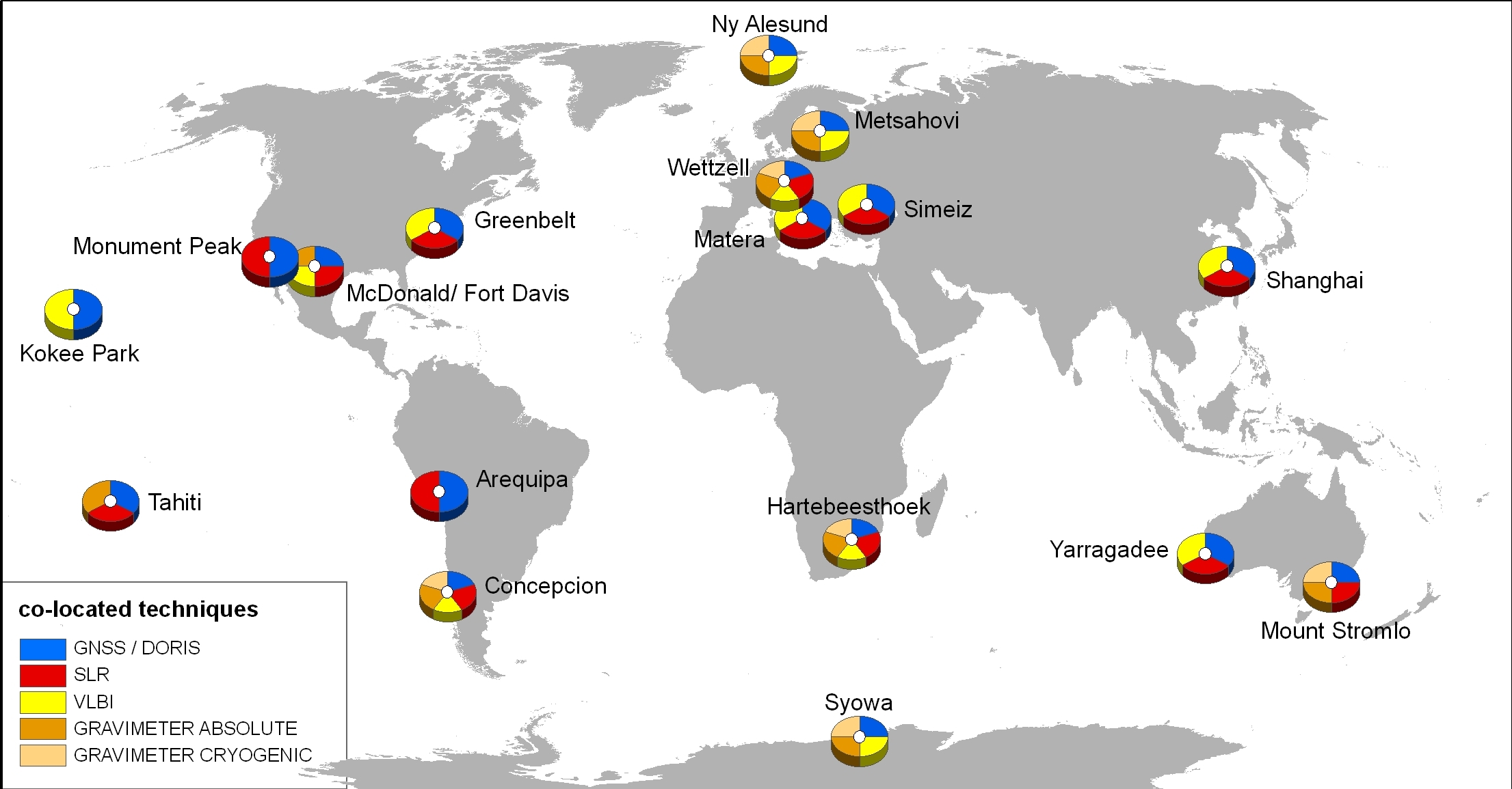
In the late 1990s, more than 20 core station existed, as demonstrated by the larger number of core stations used for the determination of ITRF2000. However, there are only 15 core sites with three or more of the space-geodetic techniques, and in fact only 9 stations with permanent GNSS, SLR and VLBI observations.
Fig. 1 Current network of geodetic observatories (core sites).
Voluntary committing observing stations and analysis centres can discontinue their operation due to a lack of funding and political support. The international space geodesy network has recently suffered several debilitating closures and reductions in the last several years due to budgetary cutbacks.
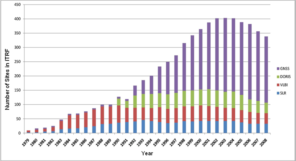
Fig 2 Evolution of the number of space technique sites used for the ITRF
GGOS2020 lacks an implementation plan.
The present organizational structure of GGOS does not include the stakeholders of the IAG Services.
GGOS needs a long-term global infrastructure.
Opportunities as a result of stronger cooperation between governmental organizations
The products of IAG services can be improved by more observations, processed data and better analysis strategies.
The existing (core) networks can be densified at regional level also in remote areas (southern hemisphere, Africa, etc.).
New stakeholders of countries with small or no contribution to IAG services may be attracted by GGOS so that the observing activities will be extended.
A stabilisation of the IAG Services strives for a permanent global infrastructure under the umbrella of an intergovernmental institution.
Coordinated decisions of stakeholders of IAG Services will advance the common goals.
The core network densification will be an opportunity for know-how transfer to less developed regions
Contributions to GGOS for small or less developed countries appear to be easier, if an international umbrella institution would exist.
Threats
IAG Services as backbone of GGOS are strongly dependent on the economical situation and are frequently facing budget cuts.
Lack of visibility of GGOS and in particular the products of the IAG services.
Political decisions did not recognise the concepts of geodesists.
Financing GGOS and IAG Service activity as a short-term scientific project does not lead to sustainable products.
The GGOS Intergovernmental Committee (GIC) will task to support GGOS in attaining its goals by
appropriate intergovernmental agreement that facilitates planning, securing, and maintaining the geodetic infrastructure and operation of the services according to the needs of science and society;
representation and promotion of GGOS to international entities that require intergovernmental representation (UN, etc.)
The
Committee shall be comprised of Active and Associate Members.
Any
national body or national organisation which is responsible for
supporting the global and regional geodetic
infrastructure may become an Active Member.
Each Active Member of the Committee shall designate a representative who may be assisted by alternates, advisers and experts.
Associate Members are other international governmental and non-governmental organizations, who are willing to support the GIC tasks.
In addition, ad hoc observers are also able to participate in the meetings of the Committee after having receiving accreditation by the GIC.
To strengthen structurally and administratively the global geodetic observation services and the infrastructure they are based on, and to secure their long-term operation
Be responsible for the installation, maintenance and development of the GGOS core network,
Support of IAG Services (networks, data archives, analysis centres, geodetic standard products …)
Be responsible for the monitoring of GGOS core network and basic GGOS operations
Identify the resources needed for the basic GGOS operations and the means for obtaining them
Maintain liaison with IAG/GGOS in respond to research needs
Government representation, e.g., in GEO (does not remove IAG/GGOS as a participating organization)
Maintenance of the liaison with GGOS through representation in the new GGOS governance structure
(Will be discussed during GGOS Retreat Feb. 1 – 4, 2010)
Intergovernmental Committee
An intergovernmental organization, sometimes rendered as an international governmental organization and both abbreviated as IGO, is an organization comprised primarily of sovereign states (referred to as member states), or of other intergovernmental organizations. Intergovernmental organizations are often called international organizations, although that term may also include international nongovernmental organization such as international non-profit organizations (NGOs) or multinational corporations.
Examples
World Meteorological Organization (WMO)
specialised agency of the United Nations for meteorology (weather and climate), operational hydrology and related geophysical sciences
Intergovernmental Oceanographic Commission (IOC)
http://www.ioc-unesco.org/index.php?option=com_frontpage&Itemid=1
Established in 1960, the IOC of UNESCO promotes international cooperation and coordinates programmes in marine research, services, observation systems, hazard mitigation and capacity development in order to learn more and better manage the nature and resources of the ocean and coastal areas. The IOC is instrumental in monitoring the ocean through the Global Ocean Observing System (GOOS) and developing tsunami warning systems in vulnerable regions.
International Hydrographic Bureau (IHO)
http://www.iho-ohi.net/english/home/
In 1970, an intergovernmental Convention entered into force which changed the Organization's name and legal status, creating the International Hydrographic Organization (IHO), with its headquarters (the IHB) permanently established in Monaco. The Organization currently has a membership of eighty maritime States, with several others in the process of becoming Members.The International Hydrographic Organization is an intergovernmental consultative and technical organization that was established in 1921 to support the safety in navigation and the protection of the marine environment.
Group on Earth Observation (GEO)
http://www.earthobservations.org/about_geo.shtml
The Group on Earth Observations is coordinating efforts to build a Global Earth Observation System of Systems, or GEOSS. GEO is a voluntary partnership of governments and international organizations. It provides a framework within which these partners can develop new projects and coordinate their strategies and investments.
GEO was launched in response to calls for action by the 2002 World Summit on Sustainable Development and by the G8 (Group of Eight) leading industrialized countries.
Interagency
Involving or representing two or more agencies, especially government agencies.
Examples
Inter-Agency Space Debris Coordination Committee
http://www.iadc-online.org/index.cgi
The Inter-Agency Space Debris Coordination Committee (IADC) is an international governmental forum for the worldwide coordination of activities related to the issues of man-made and natural debris in space.
International Group of Funding Agencies for Global Change Research (IGFA)
The goal of the International Group of Funding Agencies for Global Change Research (IGFA) is to foster Global Change Research. IGFA is a forum through which national agencies that fund research on Global Change identify issues of mutual interest and ways to address these through national and when appropriate through coordinated international actions.
Regional intergovernmental committees:
Intergovernmental Committee on Surveying & Mapping (ICSM)
ICSM's role is to provide leadership, coordination and standards for surveying, mapping/charting and national datasets.
United Nations Office for Outer Space Affairs (UNOOSA)
The United Nations office responsible for promoting international cooperation in the peaceful uses of outer space serves already as secretariat for
United Nations Committee on the Peaceful Uses of Outer Space
International Committee on Global Navigation Satellite Systems (ICG),
maintains a 24-hour hotline as the United Nations focal point for satellite imagery requests during disasters and manages the United Nations Platform for Space-based Information for Disaster Management and Emergency Response (UN-SPIDER).
18. UN regional Cartographic Conference for Asia and Pacific and Other Regions
http://unstats.un.org/unsd/METHODS/CARTOG/Asia_and_Pacific/18/Report/English.pdf
Resolution on a Global coordination of geographic information management including consideration of the possible creation of a United Nations global forum
The Conference,
Recognizing the absence of a United Nations consultation process led by member States, which deals with global geographic information management, coordinates regional efforts, promotes global norms on geographic information and brings such information to bear on global issues,
Also recognizing the requests of member States for a global mechanism, the work to develop common frameworks and tools and a process of standardization, for which the United Nations has a key mandate, to address the need and the necessity for experience exchange and technology transfer on geographic information tools and infrastructures, with specialized, regional and international organizations,
Requests that, by 1 November 2010, the Secretary-General and the United Nations Secretariat initiate discussions and prepare a report, for a future session of the Economic and Social Council, on global coordination of geographic information management, including consideration of the possible creation of a United Nations global forum for the exchange of information between countries and other interested parties, and in particular for sharing best practices in legal and policy instruments, institutional management models, technical solutions and standards, interoperability of systems and data, and sharing mechanisms that guarantee easy and timely accessibility of geographic information and services.
Intergovernmental Committee (GIC) comprising the governmental organizations that contribute to the GGOS core network (= General Assembly)
Management Board (MB) to be elected by the GIC
Chair and Vice Chair to be elected by the MB for a period of 2 years
Secretariat